Five years ago, I lived in Leeds for half a year, and never once visited Kirkstall Abbey – one of West Yorkshire’s most popular sites.
So finally, I revisited Leeds in 2017 and could say I stepped foot into Kirkstall Abbey. It was a rainy Tuesday in October, and I had the entire place to myself.
The Abbey was founded in the year 1152 by Henry de Lacy, a significant landholder of the North, and occupied by a group of monks. It was later surrendered to Henry VIII during the Dissolution of the Monasteries in 1539. Two centuries later, the ruin became popular for Romanticists, especially poets and novelists, looking for inspiration. When Leeds City Council took ownership of Kirkstall in the mid 19th century, restoration work began and has been ongoing ever since. It is one of the most intact Cistercian monasteries in Britain.
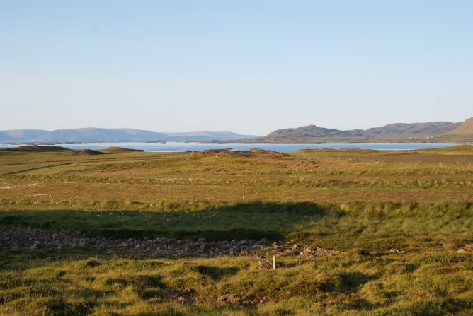
Kirkstall rests peacefully along the River Aire outside the city, surrounded by trees and parkland, emitting a pastoral charm to visitors. Today, the Abbey hosts creative workshops, markets and even movie nights in the summer (2001: A Space Odyssey under the stars would be quite the celestial experience).
But there was nothing going on today. The only signs of life were two welcomers in the Visitors Centre, located in the Abbey’s Reredorter. Yes, a reredorter translates to “latrine.” So, the entrance was also where the lay brothers once relieved themselves. And people still do today – privately of course, with modern infrastructure in place.
Entering the Abbey was free admission. I calmly strolled through the ruins, cowering under my umbrella as the rain fell steadily and echoed off the stone walls. I felt like an Impressionist, seeking an aesthetic revelation for my next painting.
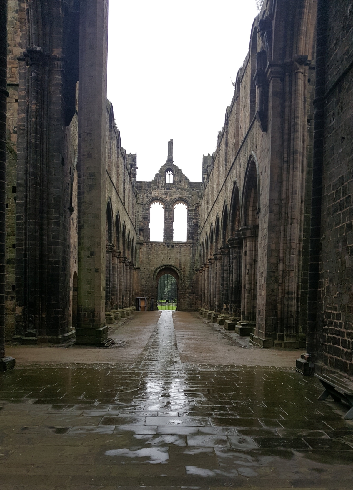
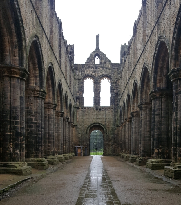
I took some shots of Kirkstall’s largest sections – the Nave and the Tower. I had a perfect angle to accentuate its symmetry, with a grated archway directly in the centre. A beam of light from the sky illuminates the middle aisle from the doorway.
Kirkstall Abbey – Nave
I huddled inside the cloisters and put on some music, listening to some mellow Pink Floyd tracks. It was probably from Echoes or Meddle.
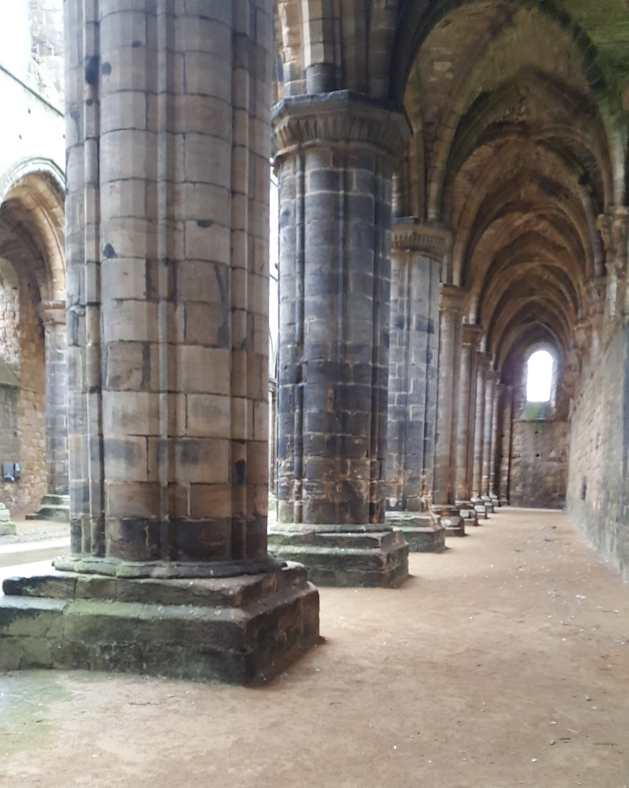
Pillars of ambiance
The Abbey also had a great courtyard – resembling the grounds of Hogwarts (a cultural attribute akin to all British castles).
Even with a mediocre camera phone, I was impressed by the light and shadow contrasts from inside looking out. Although it was rainy, the sky provided ample brightness on each and every brick and crevice.
The Cloisters
I spent at least an hour wandering through every room – the old Chapter House, Parlour, Refractory and much more.
Still sheltering from the rain, I crossed the street for a quick glance at an old cottage – of course, looking straight out of a Jane Austen novel.
I caught a bus back to the city, running on a tight schedule to retrace my old stomping grounds.
Kirkstall Abbey now welcomes its doors to all but especially appeals to Romantics, medievalists, shoppers or moviegoers. However, I created my own experience as I stepped into somewhere new within a familiar place. I felt spirits of the monks, once present 800 years past re-awaken amidst the emptiness and eeriness – a perfect pre-Halloween experience.
And naturally, as a historian, I was impressed by how well Kirkstall has been preserved. It truly reflects Britain’s commitment to preservation comparably unseen in Canada.
For those nearby who want to visit but avoid the crowds, go on a rainy Tuesday!
As my blog continues to grow each week, I am now on Instagram! Please follow me: @finding.sonder
My primary focus will be this blog, but Instagram will be my extra creative outlet on the visual side. I hope to share more photos of my travels and link back to blog posts – old and new.
On a cloudy September day, I was cordially invited for afternoon tea at King Ludwig II’s castle.
Well technically, I invited myself weeks in advance. By purchasing a ticket. And sadly, poor Ludwig’s been dead for over 130 years.
His hosts ran a tight schedule in order to accommodate thousands of guests. If you failed to pick up your ticket 90 minutes prior to your tour, it would be canceled.
My journey there didn’t go as planned, despite an early departure. It was two and a half hours by train from Munich to Füssen through the Bavarian countryside. I missed the previous direct route and hopped on the next train, which was over an hour to Buchloe, and change to Füssen.
My arrival in Buchloe was ill-timed. Once again, I barely missed a train, and the next one was in half an hour. That also arrived late. Finally, in Füssen, my last journey was 10 minutes by bus from the station. The bus sat there for another 20 minutes before it finally departed.
The transport gods really wanted to spite me that day. About 2 km outside our destination, my bus got stuck behind a giant parade, marching downhill. Fortunately, the bus driver bailed us off, as walking was our only accessible option.
It was officially past the cut-off time. I had nowhere else to go and needed a backup plan. Should I just visit the castle from the outside? Walk to Austria? The border was a few kilometres away.
I found the ticket office nearly half an hour late and waiting for the moment of truth. I approached the ticket counter with my confirmation in hand, hoping I’d still get in. After all the hassle and late arrival, they let me in!
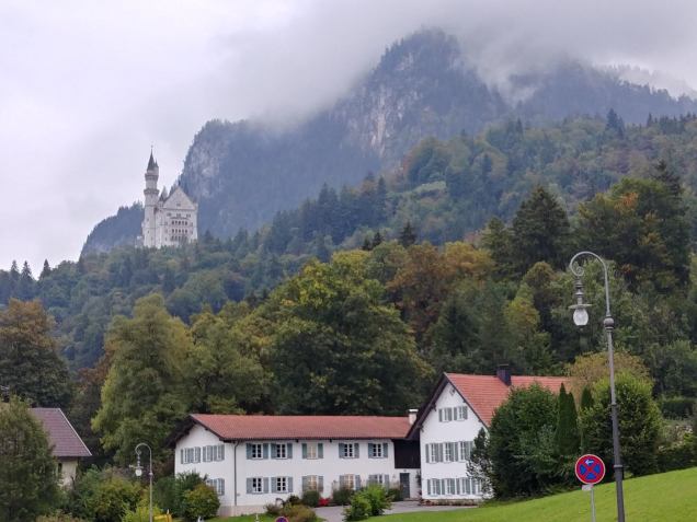
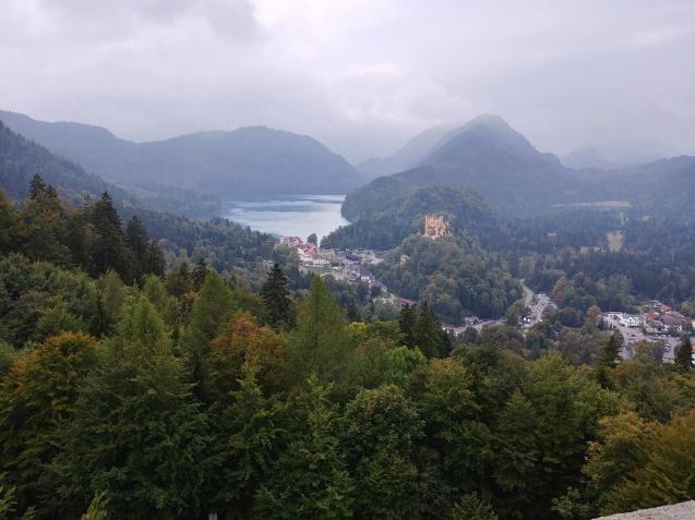
From the village of Hohenschwangau, I saw a lonely, white Disney-style castle, nestled in the Alps which loomed above. In perfect fairytale fashion, the clouds were ominously low over the mountaintops. I imagined the king once occupying this fortress, distancing himself for his own fantasy world. This palace was his dream, manifested to physical form and isolated from daily mundane affairs.
Neuschwanstein from Hohenschwangau
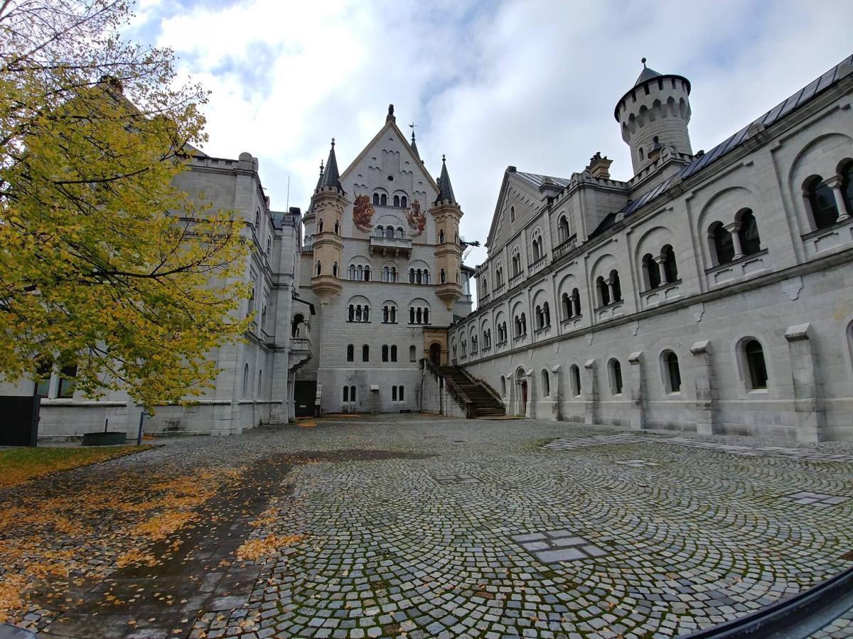
King Ludwig II’s legacy was synonymous with luxury and extravagance. Since he was crowned King of Bavaria in 1864, he exercised little financial restraint to follow his personal ambitions. Ludwig was entranced by the idea of a holy kingdom full of grandeur and artistic opulence. Thus, Neuschwanstein was one of his biggest architectural endeavours, commissioned and built between 1869 and 1872.
Neuschwanstein was truly a first of its kind, modeled from old Romanesque styles and mixed with medieval imagery and German historicism. Interestingly, the castle’s interior was also fitted with modern technological concepts, notably electricity, heating and plumbing, a stark contrast from the austerity of its exterior.
As the castle came into being, Ludwig increasingly withdrew from Munich, focusing on a new life filled with operas and plays, all performed for him only. Seven weeks after his death in 1886, the castle opened to the public and now hosts a maximum of 6,000 visitors a day. Ludwig’s dream palace made for seclusion is now bringing the world to its doorsteps.
From Hohenschwangau, it was a 20-minute walk uphill to the castle. I entered the forest and followed the path upwards as horse-drawn carriages shuffled past.
Can’t have a medieval castle without an enchanted forest
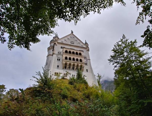
I could see the castle’s top turret as I got closer. During my walk, I had put on music for some ambiance. I waited until this moment to play some Chilly Gonzales and drown out the chatter of crowds with the whimsical chimes of his piano.*
“Rapunzel’s” tower
I reached near the top of the footpath, catching my breath and feeling a mild burn in my legs. After the trouble getting here, I had 30 minutes to spare before my tour.
The tinkling of piano filled my ears as I circled around the base of the castle.
East-facing balcony from below
I noticed Ludwig’s “caretakers” were keeping his home in top shape. Restoration work was underway near the Knight’s House on the south section, with scaffolding covering its base.
The rear under construction
My group was called to the entrance at 1:50 p.m. Of course, it wasn’t Ludwig who greeted us, but a tour guide holding audio headsets. I pictured Ludwig’s reaction over hundreds of guests a day trampling through his private quarters, getting up close and personal to his exquisite art collection. I felt a little bit guilty.
Despite a short tour, the inside was quite spectacular, with medieval and religious imagery painted all across the floors, ceiling, and walls. They displayed motifs of love, repentance, and salvation with images of knights and poets populating the walls. With audio sets on, the guide directed us through the servants’ and administrative quarters on the lower level, then to the king’s staterooms on the upper floors.
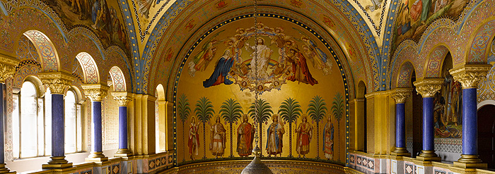
One of the biggest rooms, the Throne Room, truly exemplified his fixation on medieval lore, especially the Holy Grail. The real story, no Monty Python references here. The rectangular-shaped room is bordered on either side by blue pillars with the sunlight shining on the golden walls. Ludwig intended for this to be the Hall of the Holy Grail, a reincarnation of his obsession with purity and freedom from sin.
Throne Room- Indoor photography was prohibited, so this image is also from their official website
The upper level opened up to an exterior balcony facing the Alps with the river Pöllat running through. Being mid-September, the trees were already beginning to change colour. Meanwhile, I put myself in Ludwig’s shoes (or boots), standing where I stood, watching the river and the trees bloom, still and introspective. Removed entirely from the turbulent affairs of his country and the rest of Europe.
View of the Pöllat
Behind the castle, low clouds enveloped the peaks and cliffside.
View of Hohenschwangau from the balcony
As the tour concluded, I stopped at the gift shop and purchased a fridge magnet. For every trip, I always needed that one cheesy souvenir.
My visit with King Ludwig had come to a close. I bid good-bye and started my trek downhill. On the way, I stopped for an exceptional view of the landscape facing north. During my last two hours, I took the bus back to Füssen to explore and eat some ice cream before hopping on a train to Munich. By then, Neuschwanstein has disappeared, retreating to the mountains just as the aloof king once did.
Quite füssed about Füssen
Admittedly, Neuschwanstein was a little outside of my taste when it comes to travel. I love tourist attractions – don’t get me wrong – but when abroad, I strive to embody the explorer or wanderer rather than a tourist. Well today, I was certainly a tourist.
To some, the castle could be considered your typical run-of-the-mill tourist trap and not worth the money and time. I certainly had some reservations myself, especially throughout my travel snafus.
But to me, Neuschwanstein was anything but inauthentic. If you look past the touristyness, here’s a place both ahead of and past its time. A place brought to life by a man conflicted with the burdens of everyday life, who felt disconnected from society. Thus, he found purpose through an alternate reality, shaped by his imagination.
Both the castle and its grandiose symbols of medieval fantasy demonstrate a paradox: As Ludwig’s world grew bigger, the outside world began to shrink around him – every single day. And now, this once reclusive place opens its doors to outsiders from all around the globe.
I bet Ludwig wouldn’t be too happy about that.
*For some music to chip away your writer’s block, take a listen to some Chilly Gonzales
Historical info about the castle and Ludwig was from their website. Click here for more background information.
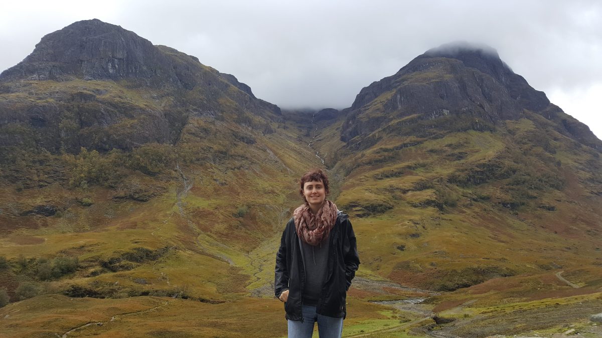
In the fall of 2017, I did my first solo backpacking trip. I spent nearly four weeks touring England, Scotland and Scandinavia as a Masters graduation gift to myself.
Now that summer is fading and my favourite season is around the corner, I started reminiscing on my autumn adventures. It took months to craft an itinerary suitable for an aesthetic experience of October’s fall colours. Although Scandinavia has similar geographic attributes to Canada, I was also drawn to its cultural and historic traits. I hoped to meet others from around the world, and quite frankly, go somewhere far away for a while. I hope within the next two months to share some more images I took of autumn in Scandinavia.
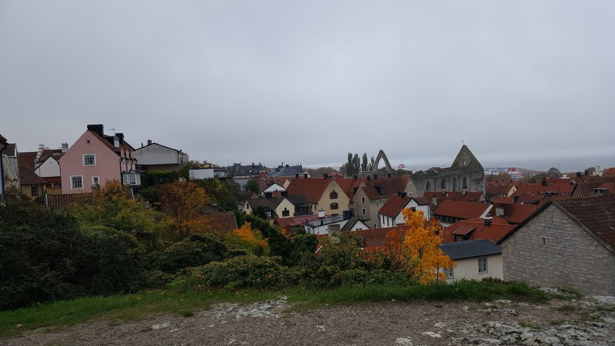
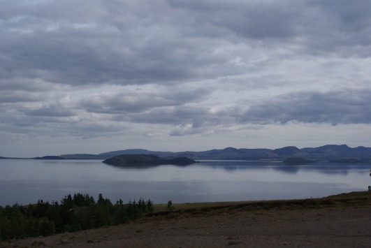
Today, I recount my special getaway within a getaway. After two busy weeks of cities, planes, trains and automobiles (or tour buses), I ventured off the mainland by ferry for a quiet two nights on the island of Gotland and the medieval town of Visby.¹
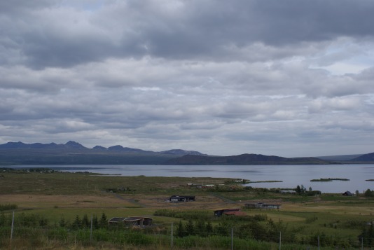
Gotland is the largest island in the Baltic Sea, a major Viking settlement and an archaeological playground of rune stones and burial sites. With summer being high season, Gotland offers local Swedes an escape to the beaches, cycle through green meadows and along the coast, bird-watch or go back nearly 1000 years in time.
Visby, Gotland’s biggest town, was the epicentre of the Baltic’s Hanseatic League between the 12th and 14th centuries and currently a Unesco World Heritage Site. A remarkably preserved medieval wall encloses the city. Once designed to protect a trading metropolis, the wall fueled tension, leading to civil war in 1288. Even afterward, Visby faced invasions from both the Danish army and pirates leading up to its decline of power by 1525. The town later grew beyond its walls again by the 19th century. Many of the limestone buildings, especially dwellings, warehouses and churches in Romanesque and Gothic style, remain intact.Overall, Visby appealed to me with its historical authenticity and relative isolation.²
I woke up early on the morning of October 17, departing Stockholm after four nights. It was an hour by train to the port of Nynäshamn, followed by a three-hour ferry to Gotland. Often erring on the side of caution, I showed up much too early. The trip at sea was calm and smooth-sailing, with ample room to sprawl out and nap.
After docking, I hauled my backpack over my shoulders for the hundredth time and looked up my guesthouse on my phone. It was supposedly a small cottage in the centre of town, uphill and easy to miss.
The sky looked hazy with the sun poking through like an orb from a magnifying glass. The air filled with the whooshing sound of crashing waves, feeling fresh on my skin. I knew instantly this was where I needed to go.
While I was lost looking for my accommodation
In the meantime, I was beginning to regret my choice of accommodation, because of how long it took me to find it. 45 minutes in, I was triple checking my map and starting to sweat (and cry a little). When I found the guesthouse, there was hardly any sign. As seen in pictures, it was tucked away off the main street. I punched in the front door’s passcode and entered a white cottage with two floors, a front porch and a separate little red shack.
My regret disappeared once I stepped inside. There was no reception, except for a welcome sign with an email and phone number and a kitchen at the end of the hallway. I was sure I had the entire place to myself, except for one other woman who occupied the room beside me.
My room was adjacent to the living room, separated by the door. It was decorated in a perfect Scandinavian fashion of comfort, simplicity and functionality.
I knew this weekend in Visby would be an ideal retreat from the city. Yet I found myself missing Stockholm like crazy and this was the perfect antidote.
Even an Ikea showroom couldn’t beat this
It was getting close to the evening as I took another nap and gathered my bearings. I briefly met the woman staying next door on her way to meet friends. She was a recurring visitor once a year and this was always her place of choice.
The front yard and red cottage
Around 7 pm, I left to find the city centre – called Stora Torget – to get some groceries. By this point, I was accustomed to Scandinavia’s exorbitant food prices and lived off of free hostel pasta. I was still wary of my budget and year-long savings for this trip.
On a Tuesday night, there was hardly a single soul outside until I reached Stora Torget. Occasionally, ephemeral harmonies of chatter from a pub or restaurant filled my ears as I walked past, then faltered. The streetlights illuminated narrow cobblestone streets, limestone walls and red-roofed houses. It felt like midnight in a storybook setting. I was the main character, an alien observer from the outside looking in.
Anybody there?
I purchased bread, cream cheese and smoked salmon for dinner and some snacks for afterward. The guesthouse was empty, and I capped off the night on the couch with a book until it was bedtime.
A real “bustling” metropolis
After my first night, I only had one day to explore Visby. Despite the trouble I had locating my guesthouse, the town was quite simple to navigate once I got accustomed. I observed Visby’s colourful layout of yellow, white and orange enclosed by grey medieval walls. The autumn hues added even more personality to this antiquated city. The sky was still overcast, bringing a chill to the air, the road glistening from overnight rainfall.
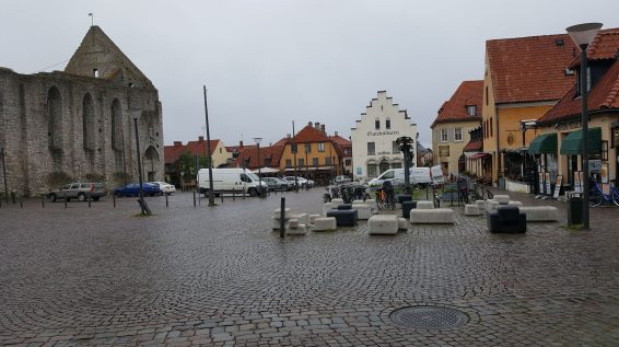
Stora Torget
As I walked through Stora Torget in daylight, I examined the ruins of Sankta Karin. Dilapidated on the inside, the monastery was built by the Franciscan Order around roughly 1250. Its exterior was mostly intact but hollowed out in the middle, with the roof missing entirely. When I stood by the entrance, I peered through the interior and its narrow arches and adjacent pillars. What used to be ornate stone floors and stained glass windows are now tufts of moss and empty window slits.
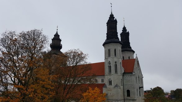
While checking my map, I noticed the Visby Cathedral marked uphill, about a 10-minute walk from Stora Torget. The cathedral, built for German traders in the 13th century, is still in service today. The inside was beautifully preserved with altars, organs and pipes all in quality shape – a stark contrast to its more derelict counterpart.
Visby Cathedral
I wandered through the church courtyard, observing aged tombstones about four-feet high, casually leaning against a wall. It looked like the groundskeepers simply left them there many years ago and promptly forgot about them.
Along the wall was a narrow stairwell leading upwards to a hilltop vantage point. Once I reached the top, I was treated to a complete panorama of the city in its compact and medieval form with bright red and orange trees poking out from the streets. I scanned beyond the coast which enveloped the island. I could even see my ride docked at the harbour and the giant “G” painted on top.
Vistas of Visby
A light breeze from the water rustled the trees, simultaneous with the chiming of church bells. Taking in all visual and aural senses, I felt truly in the right place at the right moment.
Lunchtime was approaching, and I found a nearby cafe by my guesthouse. I splurged on a cappuccino and ate an entire crêpe filled with crème fraîche, beans, pickled onions and arugula.
Forgetting that I had less than 24 hours left in Visby, I moved on with my afternoon itinerary. Because this was shoulder season, museums and other attractions closed quite early, so I spent the next two hours enlivening my taste for Viking history at the Gotland Museum.
I perused collections of Viking and medieval icons, burial trinkets, jewelry and even skeletons. The main hall had enough archaeological curiosities to stroke the fantasies of both hardcore Viking and medieval enthusiasts. I thought about the time I volunteered at the Canadian Museum of History’s exhibition on Vikings. I remembered its peculiar objects, including a remnant of preserved fecal matter which determined Vikings’ dietary habits. I recalled teaching kids about why they drank mead out of their horns. And no, they did not go on helmets.
There were also picture stones held upright behind wires, towering almost seven feet high. These decorative stones were memorials, which epitomized Viking burial culture. They honoured powerful people and their deeds, their inscriptions telling stories about one’s travels and oftentimes, their fateful end. These decorative stones can be found everywhere across Sweden. They’re as common as a backyard garden stone.
Some were in different shapes for different purposes. The ones that stood out to me were the so-called “mushroom” stone. To my amusement, the museum wasn’t afraid to admit what we were all thinking it was shaped like:
The “mushroom” stone…
After the museum, I still had about two more hours left of daylight. My ferry would depart at 7 am tomorrow, so I needed an early night.
I stopped at my guesthouse to pick up some postcards I’ve been waiting to mail. Hoping it was still open, I found a post office north of the city. I crossed through the gates of the old walls, temporarily leaving medieval Visby for its modern version. It was odd to suddenly see plazas, gas stations and fast-food restaurants on the outside. It felt like I stepped out of a time warp back into reality.
After mailing my postcards, I re-entered the time bubble back into old town. I traced my footsteps along the base of the wall, stopping to read plaques on the footpath. The round towers and window slits resembled a Monty Python set, and it reignited my appreciation for the Holy Grail. I pictured the French taunter poking his head out from the wall, hurling insults at his enemies. Two weeks prior, I visited Doune Castle in Scotland, where this scene was actually filmed.
Camelot!
As I approached the shore, the clouds scattered, revealing an evening sun and blue sky. I noticed the Catherdral’s spires and the monastery’s arches sticking out over the roofs.
At dusk I embarked on my final trek. This was the perfect time to see the waterfront one last time before morning. The ships were all docked at the harbour. Even the ferry was saddling up for its morning voyage.
A lonely harbour
I watched the sun approach the water closer and closer and then disappear, emitting a golden glow over the Baltic.
Baltic sunset
I felt lucky to have chosen this place as my vacation away from vacation. This was my first solo adventure since I studied abroad in England back in 2014. I was in search of a balance between being a sightseer and a traveler. Although I wanted to sightsee, I also yearned to belong. To go beyond the tourist attractions. Simply walk around, meet and interact with locals, find some unique place and try a new dish on the outskirts of town. At this point, I’ve achieved this balance and gotten closer to discovering what kind of traveler I am.
The act of seeking comfort and solitude is harmonious with Scandinavian culture. I remembered learning about the word “hygge” in Copenhagen – the feeling of coziness, warmth and wellness. I found such sentiment in a place like Visby.
I took this thought with me on the ferry back to the mainland. I stood outside at the top deck, feeling the chilly wind against my face as I watched Gotland, like a magical isle, disappear from the horizon.
What used to be a collection of school assignments, refashioned into a personal travel blog. After kicking this off over a year ago, jotting down and scrapping ideas, I finally have a blog name!
Introducing my new name: Finding Sonder
“Sonder” – The realization that each passerby, place or thing has a complex and vivid life of its own. Whether it’s grand or ephemeral, a story lies beneath waiting to be told. Sonder perfectly describes the curiosity of learning unique backgrounds about people or places or finding new experiences.
It was difficult to encompass my blog’s core principles into something creative, yet short and concise. While this is essentially a travel blog, I also write about short travels in my own city. It’s a home blog too. Being a history major, I’m enthralled by uncovering new narratives about both home and far away. I believe that sonder and travel go perfectly together.
Although the name may still change in the future, I feel it suits for now. New and exciting posts are to come down the road!
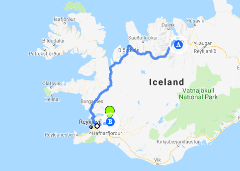
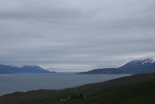
We fly home around 8:30 tonight and have the morning and afternoon to log in the last few hundred kilometres of our rental. Since we’re already in the area, we decide to spend our final hours following the pack for Iceland’s most popular tour: The Golden Circle. Self-guided of course.
After bypassing it twice, we finally choose to explore Reykjavik for the afternoon. As a retirement gift, my mom received over $250 from her friends to buy something special. She hopes that today she’ll at last use this money for a woolly sweater.
Having toured Iceland previously back in 2014, I confined myself only to Reykjavik and the Golden Circle. I’m curious to see what has changed and what hasn’t the second time around.
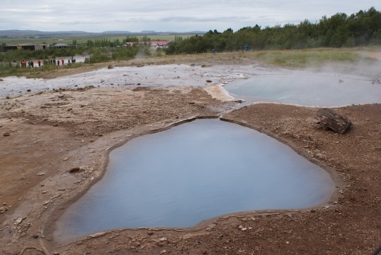
After eating breakfast, we head towards the first stop – Geysir. It’s the most popular hot spring and thermal area in the country beneath the summit of Bjarnarfell.
The park is dotted with pools of various colours and mineral mounds. The ground below has been rumbling for thousands of years, shifting according to periods of geological outbursts.
You won’t need dry ice on this movie set
As we stay to the footpath, the basins emit tiny bubbles, like a simmering cooking pot. Steam trickles out, blending with the grey clouds above. The park reminds me of the “badlands” from a fantasy movie set. The hero cautiously sets foot into enemy territory, awaiting the evil sorcerer to rise from the smoke below.
Out of all the geysers, the two most well-known are Geysir and Strokkur. The strikingly big and bright blue one is Geysir. It used to be active in its heyday, although the 2008 earthquake may have set things in motion. When something strong enough sets Geysir off, it shoots as high as 70-80m.
Here lies an old Geysir
The feistier of the two is Strokkur, also known as the Churn. Every 4-5 minutes, this pool boils over and shoots up a spout as high as 30m. I get my phone ready and recording in anticipation of capturing the explosive moment. Before Strokkur erupts, you can see a dome forming in the water, signifying what’s coming next. So how does this eruptive phenomenon occur?
I read that active geysers come from a heat source – likely magma – near the earth’s surface. The heat from the rocks would boil the water. Meltwater from surrounding glaciers also seeps through lava rock, traveling underground. There’s also a reservoir for flowing water to gather, with a vent above for water to escape. My mom explains that the bursts of water result from trapped gases below finally being released. It’s like opening a bottle of pop and hearing the fizz coming out.
After watching Strokkur erupt about four times, we slowly walk back to the car, taking pictures of smaller basins around us. There are Blesi’s twin pools, one completely opaque blue – just like the nature baths, we basked in two days prior. The other two, Fata and Litli Geysir, will occasionally make a slight splash. Streaks of yellow, brown and copper on the ground encircle the steaming bodies of water.
While they appear enticing to touch – contact would be overstimulating – literally. A sign on the pathway warns tourists of average water temperatures hotter than the boiling point at about 125° C. A quick dip of the hand will result in severe scalding.
And if that message alone isn’t clear enough, the sign also reads: “The nearest hospital is 60 km away.”
Here’s a hot spring you don’t want to bathe in
To keep on schedule, my mom and I continue to Gullfoss about a 10-minute drive east of Geysir. Here, the wind picks up considerably. It’s time to bust out the hat and both my warm and waterproof jackets.
The power of the falls intensifies with each descending step. The thundering sound of waves pounds into my eardrums. I remember feeling the same sensations when I stood here five years ago. This time around it’s gustier and cloudier, enhancing Gullfoss’ terrifying beauty. When my mom and I reach the bottom to take pictures, we’re nearly blown backward, our lenses filling with dew, our hands and faces caked with cold mist.
This must be what Niagara Falls’ Maid of the Mist is like. I’ve never done it, despite living two hours away. Instead, I get to experience something more mesmerizing in a distant country – five hours away on a plane.
The Golden Falls
The name Gullfoss likely comes from its golden tint from the evening sun shining onto the water. Another theory is when a farmer named Gýgur had plenty of gold and couldn’t bear the thought someone else possessing it once he died. Therefore, he put the gold in a coffer and threw it into the waterfall (hence, “Golden Falls”).
Gullfoss would not look the way it currently does, had it not been for a woman named Sigríður Tómasdóttir. The daughter of an estate owner, she fought to prevent the construction of a proposed hydroelectric dam in the 1920s. Although the project was approved, public sentiment inspired by Sigríður was so strong that it was never built. Gullfoss was dedicated to the Icelandic Nature Conservation Council, and Sigríður is often considered Iceland’s first environmentalist.
Around noon, we check out the gift shop before heading to Reykjavik. My mom hopes that here she could succeed in tasting some delicious Icelandic milk chocolate. Sadly, like the hot dogs, she encounters disappointment. In fact, the bar is too waxy to even consume.
While on the road my Icelandic road trip playlist comes to a near end – overplaying all the Sigur Rós and Of Monsters and Men. I end it with a bang and blast Led Zeppelin’s Immigrant Song.
About an hour later, the traffic picks up as we enter through Reykjavik’s outskirts. My mom points out – something I hadn’t noticed until now – that this is the first traffic light we’ve encountered in Iceland. Otherwise, there are roundabouts at every kilometre to control traffic. Us North American suburbanites are also curious by the absence of stop signs here.
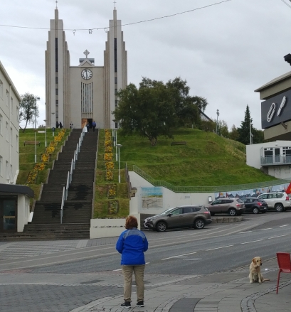
In order to find the city centre, we save the city’s legendary church, Hallgrímskirkja as our destination. Designed by our friend Guðjón Samúelsson – whose work we saw in Akureyri – the structure is inspired by the shapes of lava after it cools to rock.
Volcanic Christianity
We have about four hours to explore the city before heading to the airport. I notice how the city is even more bustling than during my previous visit. Unsurprisingly, the demographic now gravitates to more tourists than locals. More often I hear similar and different accents and languages from a myriad of places. Here, I see first-hand how Iceland’s tourism has exploded faster than a volcano.
We stop first into a tiny store of the Handknitting Association of Iceland – the place to go for woolly sweaters. After half an hour of trying on sweaters, piling the no’s on a stool and me holding our jackets and cameras, my mom settles on two favourites. However, she throws caution to the wind and needs a bit of time to think it over. I consider trying one myself, despite the hefty cost. However, I’m deterred from its scratchy sensation and my available luggage space.
Instead, I lean towards a more essential souvenir I often get from my travels – coffee. After a warm fish stew for lunch, I stop and grab my much-needed beans from the corner café called Reykjavik Roasters. My mom snaps a picture of me in this significant moment as I exit the café with coffee in tow.
As we stroll towards the waterfront, I notice some similar sights. There’s the same Icelandic café where I had my first meal beside the church. The same mini pine trees align the main drag, wondering if the hostel I stayed in still exists.
I’m especially amused to pass by one restaurant in particular. The place stood out to me because its specialty is just beer and soup in a bread bowl. That’s all you need during those cold, dark nights.
Construction appears to overtake the city’s waterfront. It makes veering onto main roads while finding the boardwalk especially tricky. Perhaps I didn’t pay attention last time, but today I notice the imposing presence of high-rise condos in this area.
Imagine having a balcony on the top floor, facing the mountains in the distance. Although my balcony has a stunning view of the CN Tower, I’m still envious. I figured this would come at a much higher price.
The remnants of Leif Eriksson’s boat?
We snap pictures of Reykjavik’s Viking ship sculpture – much like the one in Akureyri only bigger, and busier. I wait until groups of children finish climbing the sails before getting a shot of it alone.
By this point it is 3:30 and we have one hour left to walk back, including one final stop at the knitting shop. On the way, we admire the vibrant and inventive wall art on the side of shops and buildings. It was one of many things we missed out on seeing time-wise, including the infamous Phallological Museum.
Reykjavik – more like ‘Reykjahip’
Somehow, my mom finds the two sweaters she tried on before – and moment of truth. After much deliberation, she brings her selection to the counter. I follow in tow, with a smaller woolly souvenir – a pair of gloves. We exit the shop with our purchases, and it’s time to make our way to the airport.
It’s a straightforward hour drive south to Keflavik in rush hour period (equivalent to a steady flow of traffic here instead of gridlock). In a stressful moment, we nearly miss a left turn but stay on track to return the vehicle on time.
During our drive, I look out the window towards the coast, seeing the ocean we’ll be flying over, heading home. I notice the cottages and villages along the water and imagined what it’d be like to live there too. When you’re attached to a distant place, you feel inclined to picture a life there, should the future acquiesce such imagination. I know I’m not ready to go back home, and momentarily wish I could stay forever. Bring our loved ones here to be with us instead. Move to a small town in the fjords and drive around the country together.
I know I will miss the enthralling mountains and waterfalls, and all of Iceland’s most curious natural oddities: geysers, hot water, cold water, and midnight suns. It will be hard to leave the fresh chilly air and go back to stuffy summer heat. The cacophonous sounds of the city – car horns, subway rails, loud voices – will be unwelcome compared to the serenity of birds and sheep calling, and waves crashing on the harbour.
I’ll even miss the dinky white car we drove in for over 1000 km in five days (although I can’t quite say the same for my mom).
One final glimpse
We drop off the car in time and take the shuttle back to the airport. After clearing security we buy some take-home Einstöks from the duty-free and enjoy one last pint on Icelandic soil. Not realizing it was another 20-minute walk to our gate, we make a run for it and make it right when boarding begins.
As I take one last look through the plane’s window upon takeoff, I focus on the benefits of returning home to ease the pain of departure. After five days, nightfall returns, illuminated by city lights. The humidity hits us like a brick wall upon leaving the airport. It’s Toronto all over again and not Iceland. But it welcomes us back with open and very warm arms.
Despite my constant urge for adventure on the road and longing to escape, I’ll always be firmly rooted in the comforts of home.
It’s no majestic fjord or geyser, but home in its own wonderment
We gather our freshly-cleaned bathing suits and towels from the bathroom and retrieve the thermal wear from our bags. There will be another long drive ahead – about 5 and a half hours from Akureyri to Þingvellir.
Today, we are off to try something new. My mom booked us a snorkeling tour through the clear waters of Silfra, starting at 5:30 pm. She hopes to arrive about 45 minutes early, to gather our bearings. Our aquatic travel endeavours continue. This time, however, we’ll explore Iceland’s waters on the opposite end of the thermometer. From 38 to 2 ° C. This explains our need for thermal wear.
In the morning, we stroll through town to grab breakfast at a nearby cafe. On display are some of the most oddly-shaped pastries I’ve ever seen.
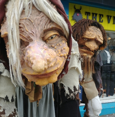
My mom buys two sugar “donuts” and for the remainder of the morning, we find ourselves amused by Iceland’s strange fascination with phallic-shaped objects (see: Icelandic Phallological Museum).
Once you see it, you cannot unsee…
Before hitting the road, we stroll along the boardwalk to take pictures of Akureyri’s various boat sculptures. One, in particular, is similar to a Viking ship seen in Reykjavik. The bright clouds from behind emit perfect shots of it as a dark, hulking shadow in the foreground.
This sail boat’s a bit too small to be sailing
After dodging traffic both ways, we get back to the car and begin our journey down south.
As previously mentioned, the beauty of Iceland is encountering new sights on familiar routes. Just like this little, flat-topped rock sticking out of the water:
This could be the tip of a giant volcano
Once again, we make numerous pit and photo stops, carefully timed to adhere to ETA.
We drive through the bottom end of the same peninsula as Day 2, approaching Varmahlíð to the south of Skagafjörður (a bay that runs along the western side). We find a drive-off point, which leads to a curious stone monument.
The pyramid-shaped memorial is about Stephan Stephansson, a famous poet who was native to Skagafjörður.
Mom the Meditative Mountaineer
A large sign in the parking lots greets fellow tourists. An excerpt reads:
“The inhabitants of Skagafjörður will only consider underground cables as the means of transmitting electricity in the future. The Icelandic National Grid’s plan to erect 30m high steel pylons with overhead lines capable of transmitting 560MVA of power through Skagafjörður. This will not be accepted.”
Apparently, Iceland generates the most energy per capita in the world.
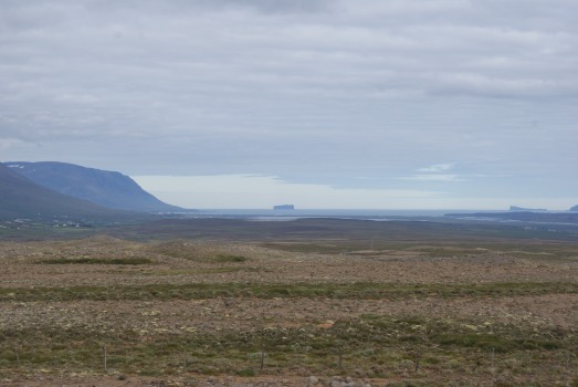
When we drove out of Blönduós two days ago we climbed to a high elevation with an incredible glimpse of the landscape from miles ahead. This time, we see it again from the other side, instead of looking back.
Same place, same wonder and awe
Today in Blönduós, we once again find the infamous N1 gas station and hot dog counter. It’s a little less chaotic this time around. We avoid the hot dogs and just grab a Pepsi. My mom brings up the possibility of visiting the Textile Museum. But as per usual custom on this road trip, we have a tight schedule ahead.
After fiddling around for probably the thousandth time with the reverse, my mom backs out of the station, gases up and we continue on.
We push back down highway 1. For the first time in three days, the sunlight returns, and the temperature climbs back to about 16 degrees. Only three hours south really makes a difference in this country.
To our right lies the same crater that we hiked before. If we had time, we could have attempted the larger one behind it. But my mom is also feeling inquisitive about the strange rock formations lining the roadside, covered by a layer of taupe coloured moss. She pulls into a nearby hotel parking lot to take pictures.
Iceland: Where topography changes quicker than the weather
Around 3 pm, we make our final stop at a gas station outside Borgarnes to stretch our legs, soon to approach Reykjavik where we’d turn east towards Þingvellir National Park (pronounced “Thingvellir”).
It’s Borgarnes for the third time, and back across the same tunnel underneath the inlet that we took leaving Keflavik. By 4 pm, we’re almost there, and the traffic increases. The highway fills with camper vans heading towards the same destination.
One final stop for some more pictures before meeting our tour guide:
Not a single ripple in this pondThe outskirts of Þingvellir
After finding the right lot, we park at Þingvellir and gather our belongings. At this point, I stow away my camera in the trunk (hence the lack of photos here), due to its obvious unsuitability for snorkeling.
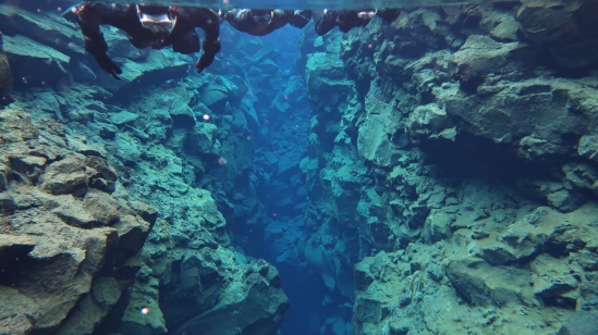
If you could mark one place on a map to define Iceland’s coming-of-age story, it would be right here.
A huge rift is currently taking place and has been for ages. I don’t mean a political rift, but an actual rift, in geological terms. Þingvellir marks a boundary between the North American and the Eurasian tectonic plates – 4 km wide, and 40 m deep. And it’s expanding by about 2 cm every year. Immediately towering over us, is the North American plate, easily accessible for visitors to climb. The Eurasian lies in the distance, like a scar in the landscape.
Can you spot the Eurasian plate in the distance?
Can you also believe that the world’s oldest surviving parliament began right here?
In the early 10th century, Iceland’s 36 chieftains gathered at Þingvellir to form a national government called the Alþing (“General Assembly”). Held for two weeks every summer, chieftains and even citizens came to settle disputes in court, trade, gossip and mingle with one another. It’s like one giant picnic or annual summer music festival, but with important business to discuss. Adopting Christianity was also something the Alþing brought about. Even into the 19th and 20th centuries, the site remained historically significant, housing a hotbed of Icelandic nationalism. In 1944, half the country gathered to declare independence from Denmark.
As evident, this place is a pretty big deal. But today, we’d remember it as the spot where we snorkeled in the coldest water imaginable. And lived to tell the tale.
Close to 5 pm and we find our tent to register and get into our suits. Knowing we’d be exposed to water for 45 minutes in a dry suit, I make one final bathroom stop for preventative measures. We put on two layers of socks – one pair of thermal ones – leggings and two warm shirts. On top of that (literally), we slip on a black thermal onesie for extra protection. The dry suits are where it gets interesting and very uncomfortable.
Our tour guide, Lasse, instructs us to only put on the bottom half ourselves, and wait until the debriefing is finished before he zips up the rest. Otherwise, we would overheat.
During the instructional, Lasse shows us a map of where we’ll be swimming, and what to look out for. We’ll likely see no fish at this time – but other odd wonders. He warns us in advance that the part most exposed to water will be the lips.
“In Iceland when it’s cold, the usual saying is to ‘just let them go numb,'” he says matter-of-factly. So that’s what we gotta do.
Time for stage two. As we hold out our arms in a T-shape, Lasse begins yanking on the sleeves. Made of rubber or elastic, they tighten at the wrists.He then fastens a zipper along our backs to secure the torso.
But the worst part is the neck. It feels like I’m barely being choked. With each swallow, I could feel the lump pushing against the collar. And the collar itself wasn’t even tight enough. After inspecting each one, Lasse wraps an extra piece like a buckle to further tighten the neck. I take deep breaths to ease my anxiety – knowing I could still breathe normally.
By this point, I stiffen my body completely to offset the discomfort. This must be what astronauts feel like. Not surprisingly, the black flies are out in full force. But to make it worse, it’s nearly impossible to move my arms quickly enough to swat them away without choking myself. Therefore, opening the mouth is kept to a minimum. I feel like poor Randy from A Christmas Story, overdressed in his red winter suit.
He slips on our headgear and gloves (which look like oven mitts). Both pieces are designed to allow the body heat from the head and hands to warm up the surrounding water inside. Thus, as tempting as it may be, Lasse explains that it’s best to keep our hands still. Clenching your hands would pump out the warm water, and allow cold water back in. Then afterwards, it’s time for the flippers.
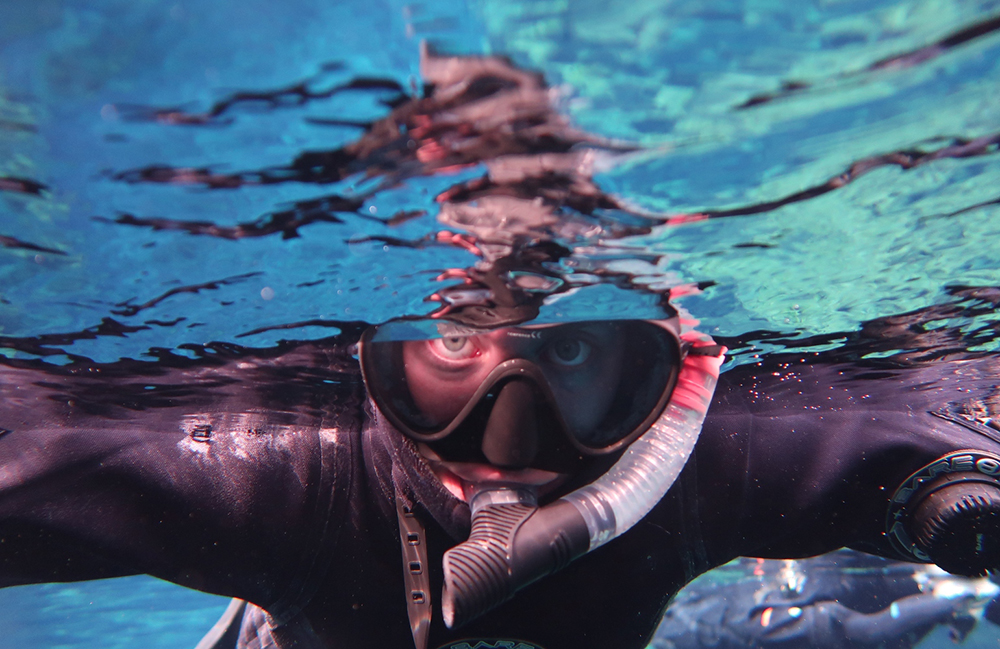
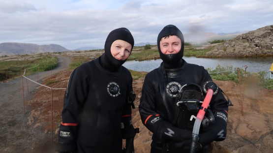
There are six of us in total all suited up: me, my mom, Lasse, a couple from Minnesota and a girl from China. We waddle along like ducks in a single file towards the entry point. Once there, a crew member helps us with the final piece – goggles and breathing tubes.
Before stepping into the water, Lasse takes a few pictures of us all snorkeled up. The hood and goggles make it nearly impossible to smile. It doesn’t help that the hood keeps covering my mouth, so I have to flip it down.
Smile wide for the camera
And then the immersion begins. I take my first step into the chilly water – but the layers and dry suit prevent any physical reactions of shock as icy water normally would. It simply feels like stepping out into a cold, winter day.
Lasse tells us to take a little sip of water. It’s just as clean – maybe cleaner – than your average filtered water bottle. I lower my face and cup it with my hands. I could feel a fresh, crisp wave filling my throat and lungs. It is invigorating.
With one leap, I lift my flippers from off the stairs. First, we practice our emergency pose before setting off. Then it’s time to reverse onto our stomachs – and I instantly feel my lips starting to sting. But I remember the old saying. The discomfort of the suit goes away entirely once floating horizontally.
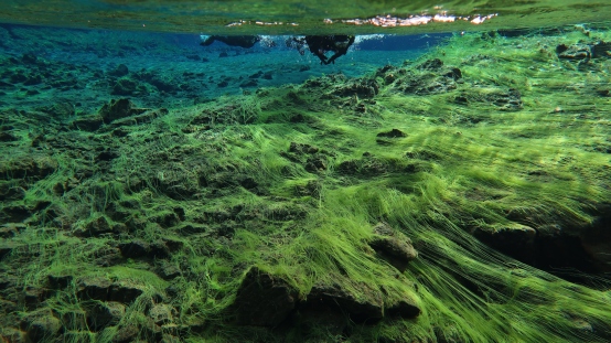
The water is so clear that I could see every crack in the rock, every spot of moss, and speck of floating organisms below. The maximum depth of Silfra is about 200 feet. The area of optimal visibility, called Cathedral, extends along a fissure of over 300 feet.
All I could hear is the rhythm of my breathing through a vacuum. I’m barely swimming right now, allowing a light current to drive me forward. I let my hands go still to contain warm water. We are wedged tightly between two rifts jutting down, sometimes into narrow crevices. Then it widens again.
If only Lake Ontario was this clear…
At one point the land bottlenecks, and we have to swim past in a single lane. I look up to keep a flipper from the snorkeler in front from hitting my face. I’m glad there are only five of us – which already feels like a crowd in some spots.
At times the sun peaks through the clouds and shines ripples on the smooth surfaces below. I occasionally flip onto my back to catch sunlight and view my surroundings. Lasse takes out the camera, encased by a clear waterproof case to take some action shots. When it’s my turn, I dip my head below the surface and awkwardly crane my head up to find the lens.
Silfra sun rays
The last turn required some moderate physical activity as the current intensifies against us. Being a strong swimmer, I enjoy stroking through the waves to obtain my exercise for the week. Surprisingly, I only just begin to feel a minor chill. But the cold really starts to creep through my hands. Just like wearing thin gloves on a cold day – my fingers start to sting.
However, I can’t resist exploring a bit more. We reach the exit and have the choice to swim to the left side for a few minutes.
It becomes very shallow – rocks are barely grazing my hands. I try my best to resist contact, due to its fragile environment. I’m entranced by the bright green moss splaying over the rocks like spider-webs, illuminated by flickering sunlight. To my surprise as Lasse helps me out, I was one of the last to exit.
Across the moss
After we regroup, Lasse takes one final post-swim shot of everyone. We take off our flippers and waddle back to the trailer.
Humanoid sea creatures emerging from the depths
Removing the suit is just as awkward – perhaps more awkward – than getting it on. One by one, we bend forward as Lasse yanks off our hoods and suits from our arms. It feels like your friend helping you pull off a dress two sizes too small in the fitting room.
We sit on a bench and stick our feet out as he removes the suit entirely. I hold onto a pole to prevent being dragged off from the force. Miraculously, once the suits are off – everything is bone dry. The only dampness is in our hair, which dries fairly quickly.
After removing our extra layers, Lasse invites us for a hot beverage and cookies. My mom and I down a hot chocolate and prepare for our final drive. We thank Lasse and say good-bye to our fellow snorkelers.
I never felt so physically and spiritually refreshed from the experience as I do now. All the tension I felt previously was relinquished. The persistent chill that I had for days is gone. This is precisely what I needed, and I feel like I can do anything.
At approximately 8 pm, we park and check-in to our guesthouse in Hveragerði, about an hour south of Silfra. Initially, we thought we wouldn’t make our dinner reservation, but luckily, an open table still awaits. We cap off the day with more Einstök, a salad for my mom, a homemade vegan “steak” for myself and a Snickers meringue pie for dessert – deciding to splurge for our final night in Iceland.
Since it’s our last night, we finally hold out to see the midnight sun – albeit lazily from our own beds. Not to mention, some kids still running around nearby and screaming outside kept us up anyway. My mom catches up on her journal, and I conclude mine.
I’m grateful that we chose to be adventurous and try something new. It’s not every day you can say that you snorkeled in 2° C water between two massive tectonic plates. The experience was remarkable. However, I’m glad to be out of those suits, and back to maximum comfort in bed.
Only four hours of sleep this time – needless to say, it was nice to sleep in.
Today there will be no long drives or busy schedules. Only one hour to Mývatn and one hour back. Today will be our spa day.
We have another full breakfast at around 10 am. This time, I double up on the coffee.
An hour east of Akureyri, the volcanic lake of Mývatn sits surrounded by craters, waterfalls and of course, nature baths. It’s time to experience Iceland’s aquatic curiosities.
We pass Akureyri briefly before heading to the pools. The city lies at the very tip of the bay, where the two sides of Eyjafjörður meet.
We cross highway 1 through the bay onto the other side and unknowingly approach a 7 km long tunnel. My mom realizes there was a sign displaying a camera hanging above the entrance, signifying a toll route.
The fjord turns into vast lowlands, with soft hills and a valley in between. Our road meanders through the heart of the valley.
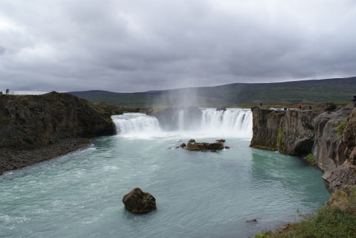
Of course, one thing we haven’t checked off our list yet was a waterfall – at least a bigger one than Ólafsvik. We considered seeing Dettifoss, the most powerful waterfall of Western Europe. But it was another hour east of the nature baths, cutting into our essential relaxation time. Therefore, we stop along the way at a significantly smaller but equally mesmerizing one – Goðafoss.
Chasing waterfalls
In the year 1000, Þorgeir, chieftain of the Ljósavatn district was faced with a choice – should Icelanders adopt Christianity as their religion? Once he decided, he threw his pagan statues into this waterfall. Thus, Goðafoss supposedly derives its name from this event – Waterfall of the Gods.
Once we are parked, my mom pays for the tunnel toll, vowing to take a more economical route on our way back. We follow the pathway to take photos and mutter about the dimwitted tourists who are jumping the fence and along the rocks to the edge.
Overall, the constant sound of rushing water soothes my overtired nerves.
Feeling entranced yet?
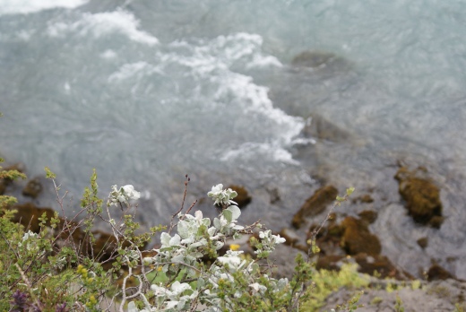
I also practice some close-up shots of floral foliage clinging to the sides with the water below.
Frosted flowers
We are now 10 minutes away from Mývatn, and the landscape alters in shape. At one point, we drive around a tiny lake – in fact small enough to be a pond. The water is so still it could have been a mirror. It’s like those Shutterstock images of hills and mountains reflected upside down by a crystal clear lake. Except this time, it’s real. Sadly, there are no turn offs to snap a picture.
The terrain starts to resemble Mars, with streaks of copper and orange splashing the hills and rocks made of lava piled up along the roadside.
Scattered among the hills in front of us are tufts of geothermal smoke billowing outwards like miniature clouds. Although a big one up ahead looks like it’s emulating right from the road.
We don’t see the spa until we are only 500 metres away after turning the bend. At first, all we could see was a driveway leading towards a mine – where the big smoke was coming from.
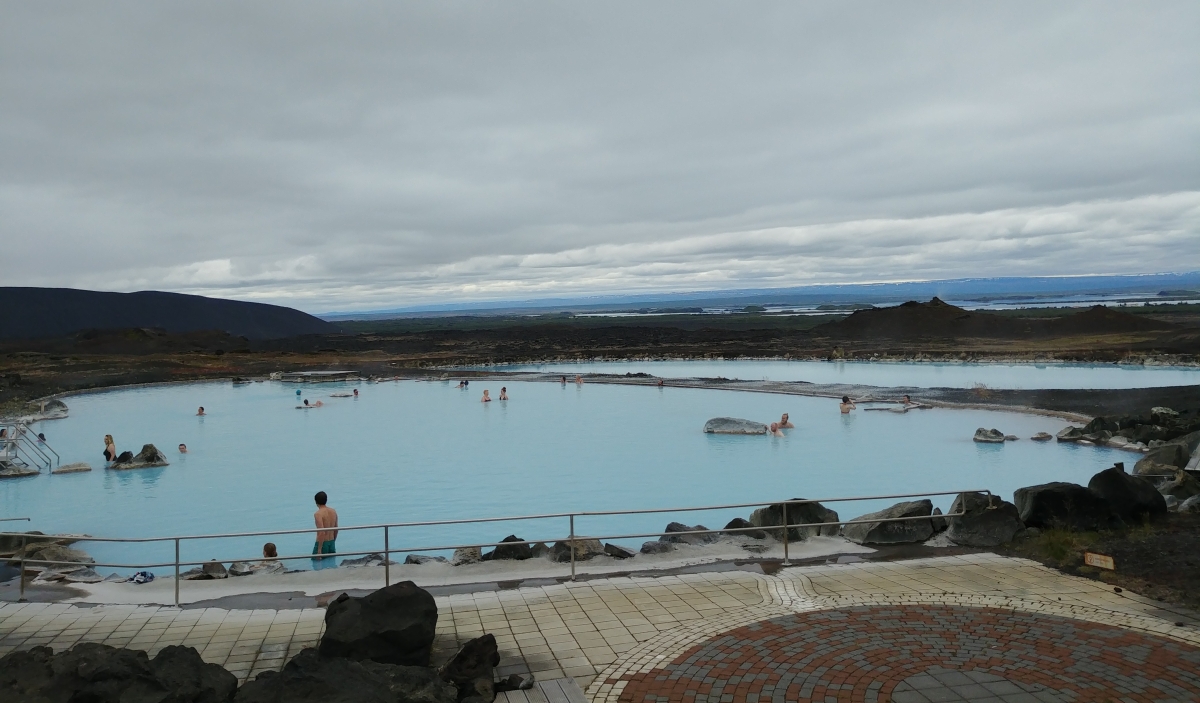
Upon parking, we bring only our swimsuits, sandals, phones, money and towels. The admission fee is hefty – but guarantees a unique experience you can’t pass up. And admittedly, it’s much cheaper and less crowded than the Blue Lagoon.
I love the smell of sulfur in the morning. Smells like serenity.
We make a cold dash from the facilities through the crisp Arctic air. Our bodies welcome the soothing heat of 38° Celsius. Our arms and legs feel smooth submerged beneath the water. We can’t see anything past our arms. It’s one of the few places where the water is both cloudy and clean.
On the spa’s slightly cooler side, we basically have the entire area to ourselves to hang out and view the breathtaking landscape. It’s enjoyable enough to distract us from the sulfuric scent of rotten eggs.
The best part is sitting on a bench (despite it feeling slimy), and relinquishing all control of my arms, allowing them to float. Then I close my eyes. I become hyper-aware of my respiratory functions. Therefore, I breathe only through my mouth, or I’d be gasping for air. It’s like meditative breathing – a full-body experience. It mutes all other voices around us. I nearly fall asleep.
We decide an hour is enough for our bodies and circulation. We grab a delicious lunch at the café, feeling like we could sit for hours on end. Once again, I indulge in the most Icelandic fashion of culinary endeavours: smoked trout on a thin slice of lava-baked bread with mixed berry Skyr and the most delicious hot chocolate I’ve had in ages. My mom has another bottle of soda – anticipating the need to combat spa-induced fatigue while driving.
We encircle the lake’s southern portion, meeting back to the same spot as before. On either side of us are small water-filled craters with rocks poking out. The land often grooves into several layers forming pits and jagged walls.
Not pictured: Hundreds of swarming flies
At one pullover, there is a photo spot as well as a guide for hiking trails. We hoped to squeeze in a hiking trek, but the flies drive us back to the vehicle. My mom had packed some mesh fly masks in her luggage – so us city folk could be bandwagon forest dwellers for a day – but sadly forgot to bring them on this drive.
On our return journey, we re-adjust our map to avoid tolls. The alternate route takes us slightly north, circling around the same fjord that my mom paid to drive through. In fact, our ETA is still the same.
Capping off the day with snow caps
And because it’s Iceland, new routes and familiar ones from opposite ways never cease to amaze us.
The clouds are high enough for us to clearly see the hilly eastern border of Eyjafjörður. As my mom slows the car around a bend, I roll down the window and stick out my camera. Luckily, I adjusted to proper shutter speed to snap from a moving vehicle.
Entrance to the edge of the earth
We pull into Akureyri around 5 pm, unload our bags and check into our next stop. Instead of a guesthouse, our lodging is a modest apartment with a kitchen and to our pleasant surprise – a washing machine. Time to diffuse the smell of rotten eggs from our clothes. We clean up and walk around town.
If Reykjavik is Iceland’s “Toronto” or “New York”, then Akureyri is the country’s “Montreal” or “San Francisco” (except north). The nucleus of Iceland’s north, the city is a lesser version of its capital, with a quieter downtown core – except perhaps when no cruise ships dock its harbour. The emphasis here is on restaurants, cafés, and bars.
But similar to Reykjavik, its church, Landakotskirkja, sits atop a hill above everything else. Travelers and locals familiar with Hallgrímskirkja would notice some identical features with Landakotskirkja. Both were designed by Guðjón Samúelsson, one of Iceland’s greatest architects.
Dogspotting and people-watching
We spend an hour browsing the shops, looking for tacky trinkets and woolly sweaters. One place, in particular, is an Icelandic version of Indigo or Coles. A bookshop with a quiet café tucked in the corner, selling various short stories, myths, and poems that epitomize Iceland’s literate reputation. My mom once heard that about 10 percent of Iceland’s population are published authors.
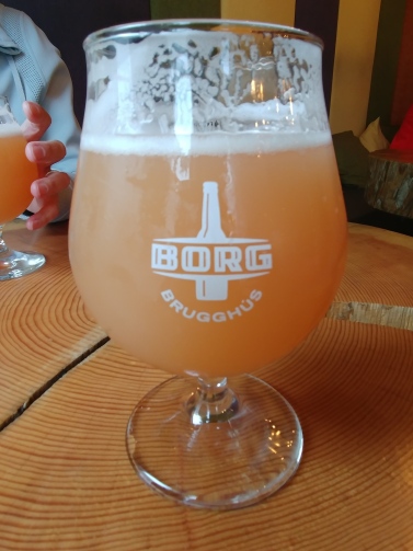
Dinnertime approaches, and our saga of finding a good hot dog continues. We spot a tiny stand during our stroll. But first, thirstiness prevails, and we cannot truly cap off our day of tranquility without a beer or two.
We check out a quiet place on the street corner called R5 Micro Bar. There are only three to four other guests inside, and the bar is just a small nook.The place is filled with different colours and a myriad of furniture styles and textures. It looks like a coffee shop, but with beer instead and resembles the culture houses I’ve seen in Oslo and Berlin on a much smaller scale. This would be my new watering hole should I ever move here.
A fitting end to a day of splurging and indulging
We both order a fruity Saison. Hunger and exhaustion lead to tipsiness after only one pint. My eyelids feel heavy, and I keep myself positioned upright to prevent sudden sleepiness.
This was me getting out of bed this morning
My mom is inclined to some bar hopping. We relocate to a busier place, with a video game corner below and a private brewery atop. I try and wake up and hold myself over by sampling some Icelandic nachos. Hint – they’re pretty much the same as here, except imported of course.
Here, we discover a rather unfortunate reality: Einstök ale is not quite the same on tap. We couldn’t even finish it.
It’s finally time for hot dogs. Now, I’m more awake, sober and half-full, with just enough room left in my stomach. But sadly, these hot dogs taste the same as they did in Blönduós. Our search prevails.
We call it a day and finish off the evening reading our books, writing journal entries and watching whatever TV channels we could find. Our bathing suits are hanging to dry, and we get our warm clothes prepared for some not-so-warm water tomorrow. While reading, I set my book down to close my eyes, not realizing that I briefly fall asleep. My mom snatches at the opportunity for an embarrassing picture.
We shut the blinds and I turn on white noise through my phone. The church bells chime their last tune by 11, bidding us goodnight.
Being naturally inclined to exploring the less-traveled routes, we chose to veer off the Ring Road and go north.
During the initial planning stages, we were allured by pictures of the Westfjords but ultimately bypassed it for timing purposes. Our destination was Akureyri via the newly advertised Arctic Coast Way.
I pulled off my sleep mask at 6:30 am. I had finally succumbed to at least six hours of sleep. The sunlight never left us and brimmed brighter from the early morning hours.
At breakfast, I filled my stomach with toast, assortments of cheese, vegetables, a croissant and a fried egg with a side bowl of skyr. At 8 am, my Mom shifted gears and chugged our tiny car slowly down the gravel road, looking for the highway.
A herd of sheep paused and surveyed us from the roadside, looking like passersby on the street watching a Ferrari zip past. They posed but didn’t smile for the camera.
Baaad company up ahead
We turned left onto the paved highway going east along Snæfellsnes. Then came the repeated and petulant squawks from the GPS echoing the vehicle. “Recalculating.” “Recalculating.” We realized that the car was heading north instead to Stykkishólmur. After my Mom pulled over twice, I realized that our intended route 54, was an extension of that same gravel road. Something our insurance plan wouldn’t particularly like.
Instead, my Mom continued to Stykkishólmur to gas up, double back and continue south to cross inland. This route took us back to Borgarnes before we veered up to Akureyri. Although our little Nissan could handle gravel, we felt uneasy about driving at reduced speed and bumping through on a half tank.
We took a quick stroll through Stykkishólmur before gassing up. Vibrant colourful houses scattered were about, some perched on round hilltops. The main street that led to the harbour stretched over water towards an island protruding 200 feet from the shore with a lighthouse resting on top. The place reminded me of a small town in Newfoundland.
The community was one of the first settled in Iceland, a popular fishing hub particularly for scallops and halibut and a mythological landmark. In Stykkishólmur the famous Erbyggja Saga recounted the life of Snorri Þógrímsson, a Viking priest and his eventual conversion to Christianity.
Stykkishólmur – secrets, sagas and scallops
My Mom filled the gas tank and hurtled the Nissan towards route 56 to the other side of Snæfellesnes. A striking characteristic of Iceland – such a narrow crossing revealed spectacles around each bend.
A fitting road movie scene with an Icelandic Jack Kerouac-style narration in the background
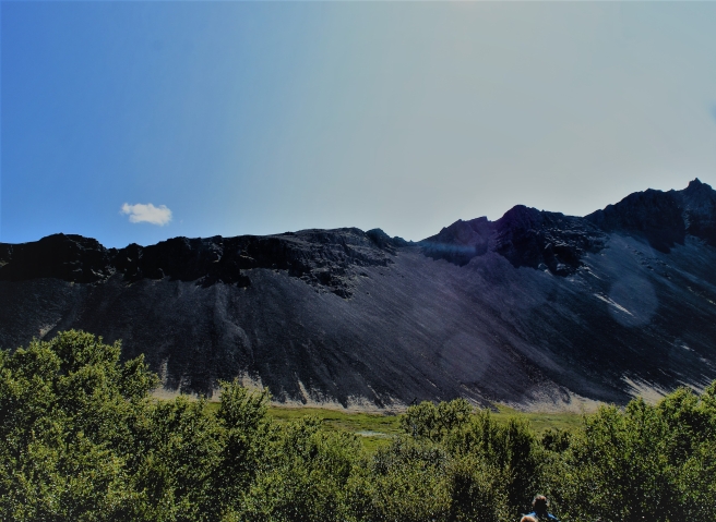
After passing Borgarnes, Blönduós was our next stop. From the passenger side, I watched the terrain morph around us, blending itself into a barren Wild West landscape and an extraterrestrial habitat. Consequently, we settled on our first impulse stop of the a day – a chain of craters.
Three of them stood in sequence from shortest to tallest. We hiked up Gràbrók, the middle one that I guessed was 100 feet high. It boasted a ripe old age of at least 3400 and its origins derived from a fissure eruption (in lay terms – a volcanic eruption sans explosion). The area now remained protected from development.
Conservation for the crater good
I followed the footpath and catch my breath from five flights of stairs, my Mom in tow. I firmly planted my boots against the path to withstand vigorous gusts of winds, strengthening by every metre I climbed. My wind-sensitive ears thanked me for bringing my hat.
We paused for photos, holding our cameras steady and watching either side for tourists. I decided it was fitting to attempt floral aesthetic with my DSLR.
Just mossing around
Adhering to our schedule, we pushed onwards to Blönduós, hoping to save time to explore its local attractions Our travel guide dismissed the small town as lacking in magnetism, save for its Textile Museum (which admittedly enticed curious lovers of material history like myself). At this moment, the busiest spot in Blönduós was the gas station and restaurant.
We endured the restroom and hot dog queues (for an unmemorable hot dog), filled up and scanned our map. After a long debate, we gave the Textile Museum a miss in anticipation for Hofsós, our next stop. I had my swimming trunks in the bag, hoping for a warm dip in their new, cliffside pool.
I watched the sun disappear and thick clouds cover the sky the further north we travelled. The outside temperature has plummeted by 8 degrees. Light rain began to sprinkle the windshield.
Pushing north and losing sun
Driving at reduced speed, we pursued a narrow road, zigzagging through green hills and valleys. It traced through the earth like a grey pencil – I could see it for kilometres from high up above. The vehicles ahead looked like bugs crawling on the pavement.
Windshield visibility decreased, due to the car’s poor quality of wipers. At this point, we couldn’t tell the difference between raindrops and the remnants of unlucky flies.
Around 4 pm we approached Hofsós. Tinier than Blönduós, this place hugs a small peninsula, almost entirely enclosed by a river. As I stepped outside, I heard nothing but the sounds of rushing water.
It’s not the English countryside – but could still be a Thomas Hardy book cover
It was July, yet I found myself layered in a thermal shirt, a windbreaker and a raincoat, unable to shake off a chill. My head was covered by both a hat and a hood, with no strand of hair poking out. Of course, blowing rain and icy wind wasn’t our idea for a pool day.
After Hofsós, our most daunting drive awaited us along Skagafjörður bay to the very top, before stopping one last time in Siglufjörður. Thankfully, the rain halted, allowing us to see snow-capped peaks, cliffs and shrouding mist over the Norwegian Sea. We were only 40 km away from the Arctic Circle.
The road was paved but occasionally giving way to gravel with little to no warning. Adding to my anxieties were landslide warning signs posted around each bend, with rocks and boulders leering above us on the mountainside. It looked as though someone held them up with firm grip on invisible strings.
With the absence of guard rails, the drive was both dazzling and dizzying. I was grateful our direction designated us to the road’s inner side.
Siglufjörður was nestled within a narrow fjord, the northernmost municipality on Iceland’s mainland. It was like a ski town burrowed within the Alps or the Rockies, cloaked by low-lying clouds.
The town was was filled with activities, but we didn’t have the time. Upon a quick stroll, we discovered the Folk Music Centre, where we could hear the chiming of old tunes and nursery rhymes. Its annual Folk Music Festival was around this time of year. And fittingly for a settlement with a bustling harbour, there was a museum for herrings.
My Mom was determined to find one particular place, hidden from the guidebooks. I followed her, until she stopped in front of a concrete, two-storey apartment building and snapped pictures from across the street. I wondered if locals were confused as to how such a plain structure could serve any interest to us. Her mission was to locate the police station from the Netflix show Trapped, which was filmed in Siglufjörður. Unfortunately, she wasn’t convinced that she got the right building.
A brightly painted town amidst the clouds and long winter nights
We started chasing time on our final leg of the journey. Leaving Siglufjörður, we zipped right through the inside of a mountain through dimly-lit tunnels. When the road got too narrow for both lanes, lucky for us, oncoming traffic had to yield.
Outside Siglufjörður, my Mom stopped the car briefly. We saw a bird with a long, thin beak perched on a sign, listening to its sharp, high-pitched squeak. My Dad guessed it was an avocet when I sent him a picture.
Our tour around the Arctic Coast Way concluded as the car turned south along the inlet of Eyjafjörður. By 6:30 p.m., we found our destination – a guesthouse about 10 kilometres north of Akureyri. Similar to the previous night, the place was a lone chalet surrounded by wilderness.
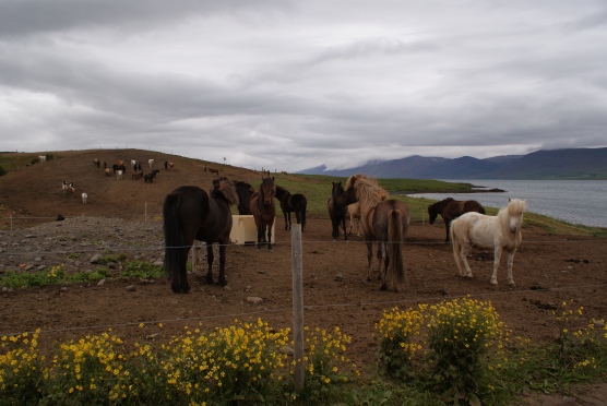
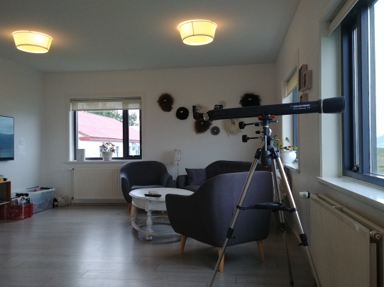
Beside the chalet was a schoolhouse sitting right on the same property, decked with murals of mythological beings and other imaginative creatures. Artwork and trinkets for sale were on display in the foyer and decking the hallways. There was a hot tub, a tree swing, a telescope for birdwatchers and a farm with at least 60 horses.
We checked in on time before our dinner reservations. My Mom ordered catfish as I indulged in some fresh ravioli. However, the purée vegetable soup appetizer was our highlight of the meal. More importantly, it was time to cap off the evening with a beer, once again.
Some shy and shaggy welcomers
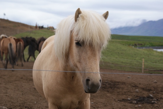
We walked towards the farm and safely approached its photogenic equines. They were roughly the same size but varied in colour – from white, to shades of brown and black. I envied their soft manes and how the wind ruffled their shaggy front mops. One curious horse was close enough to the fence for a perfect close up. Eventually, the pesky black flies re-emerged and chased us back inside.
Who is she?
I took a hot shower to shake off a persistent chill. Wrapped in a big housecoat and a book in tow, I met my Mom in the living room.
Peak level comfort and curiosity
The time was 11 pm. Looks like we’d be needing our sleep masks again.
A five-day expedition through Iceland in a dainty manual car. Just me and my Mom.
After months of planning, sprawling a big Michelin map over the kitchen table, calculating drive times and finding F-roads, it all comes down to this. We faced our challenges, all the way from Keflavik through Snæfellsnes, pushing north past Siglufjörður to Akureyri. Adhering to arrival times, tracking our impulsive photo stops, pronouncing those long names, swatting flies from our faces, watching for sheep, keeping warm and spending less than $100 for dinner.
My eyes endlessly scanning a wild, Nordic landscape, ears absorbing therapeutic sounds of birds and waterfalls – this is what months of planning were all about.
Day 1, July 6:
Functioning on seven hours of sleep in two nights, I resorted to my reserve energy supply and allowed my overtired state of mind to elevate my aesthetic experience in a strange, new environment.
We came ready to brace Iceland’s wild, subarctic elements with our windbreakers, hats and thermal underwear. The sleep masks tucked away in our purses was our only source of darkness for four nights amidst the absence of nightfall. Our economical sensibilities kicked in after months of saving. The shock of high prices certainly took our breaths away as much as the landscape. And our cameras were ready and fully-charged. We departed Keflavik airport at 11 am in a dinky little rental that could hardly reverse. Today’s destination – Snæfellsnes.
Driving past Reykjavik, we could already see the mountains ahead, contoured in the sky. Narrow streams of glacial water trickled down between the crags to the inlets below.
Mom employed some geology expertise from university to analyze these strange formations surrounding us. She said that scattered rock fragments had accumulated over the years from weathering or erosion. Eventually, these rocks, known as scree, formed a smooth, concave land formation called talus deposits.
Scree: When sediment brings sentiment
After fiddling with the Bluetooth settings, I connected to Spotify to play my Icelandic curated playlist. We turned left on route 54 to circumnavigate Snæfellsnes, a narrow peninsula jutting out into the Atlantic Ocean.
The car zipped past flocks of foraging sheep, sometimes dangerously close to the roadside. As seen in every travel guide, clusters of wild horses grazing in front of rolling hills materialized as perfect pictures from outside our window.
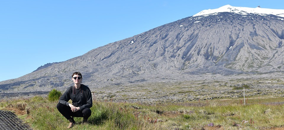
After another hour of driving, we inched closer to the mighty glacier of Snæfellsjökull, initially spotted from our plane during landing.
For literature buffs, the glacier alluded to Jules Verne’s gateway to the centre of the earth. Rumours of supernatural beings also attracted pilgrims and travellers to explore this enigmatic mountain.
Enter the centre of the earth
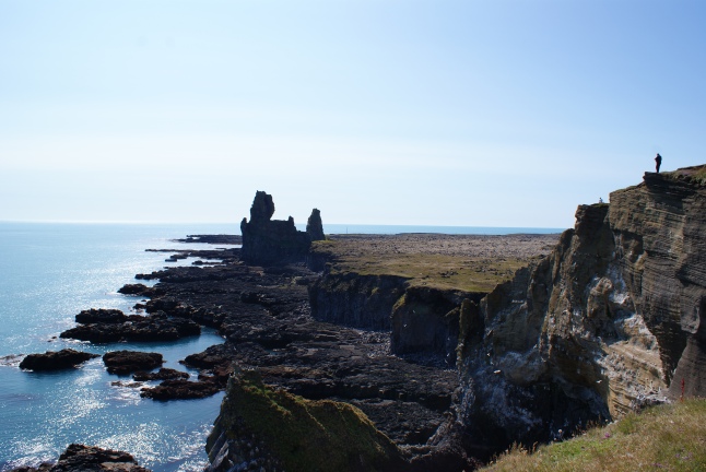
My Mom pulled the car over directly south of Snæfellsjökull, and we followed the hiking trail until we reached Djúpalónssandur – a towering cliff, jagged rocks and pebbles all perched precariously over a black sand beach. The wind was fairly gentle, carrying the sounds of waves thrashing and birds cackling. I presumed that this kind of cliffside real estate market was infinitely more competitive than Toronto’s.
Black sands of Djúpalónssandur
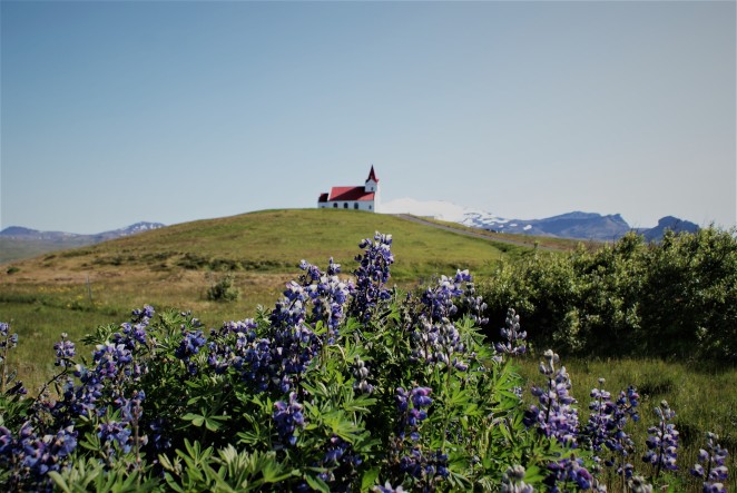
We hoped to check in by 6 pm, and timing was getting tight. After five hours into our trip, the car reached the very tip of Snæfellsnes. Along the way, a red-roofed church perched on a hill caught our eye. My Mom pressed the brakes and turned right to drive up the gravel road.
A shot of Ingjaldshóll, lonesome on a hill behind purple flowers
Serving the nearby villages of Hellissandur and Rif, Ingjaldshóll has hosted some big names in history. Heard of Christopher Columbus? According to a plaque outside the door, Columbus shacked up here once in the winter of 1477-78. Ingjaldshóll also happens to be the world’s oldest concrete church.
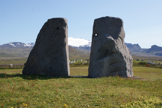
Ólafsson memorial stones
Behind the church lay two symmetrical memorial stones dedicated to the Icelandic poet and scientist Eggert Ólafsson and his wife. The pair had close personal ties to Ingjaldshóll, but sadly, they drowned in a storm in 1798 upon returning from the Westfjords. The stones were a tribute to lovers lost at sea
Our next stop was Ólafsvik, a fishing town situated on Snæfellesnes’ northern shoreline. According to my guide book, Ólafsvik is Iceland’s oldest established trading town and the most productive fishing hub on Snæfellsnes. A waterfall hugged the town’s southern border with a stream flowing all the way down towards the ocean. As we walked towards it, a family watched us from their front porch.
This waterfall was quite literally in someone’s backyard
Our stomachs started growling as dinnertime approached. In the meantime, we stared at the winding road ahead, climbing uphill (with all the pep this car could handle) and barreling downhill.
Meanwhile, I was confusedly checking Google Maps to find Kirkjufell, the famous cone-shaped feature of Snæfellsne supposedly a kilometre away. And then, a lone mountain emerged from around the bend, separate and taller than the others, curving towards the sky in both directions and plateauing on top. Without hesitation, my Mom pulled over to a viewing spot. It was that moment when I saw its shadow from the north side, that I realized this was Kirkjufell.
A witch’s hat protruding from the earth
Visitors also call Kirkjufell “Church Mountain” due to its resemblance to a church steeple. I also figured that lots of Game of Thrones tourists likely enjoyed Photoshopping Jon Snow’s face in the foreground just for fun.
Imagine a giant’s hand scooping up the land and cradling it with its hands
We left Kirkjufell, and arrived at our guesthouse by 5 pm. An isolated wooden chalet dotting the mossy countryside, it had an expansive front deck, a sweeping view, and very fresh trout.
Trout basked with mango salsa with potatoes and leaf lettuce salad. Not pictured was fresh feta in a glass dish.
We ate almost everything on our plate, even the salad – a feat I could hardly accomplish – while drinking two bottles each of Einstök ale.
Our full stomachs warranted a post-dinner stroll until our arms tired from swatting flies. It was 10 pm and the sun shone as brightly as 6 pm back home. The feeling was unorthodox – wearing sunglasses outdoors so close to midnight.
Goodnight?
Our jet-lagged selves decided to wait another time to see the midnight sun. We tucked into bed around 11, bidding goodnight and goodbye to nightfall for the next four days.


 During my last two hours, I took the bus back to Füssen to explore and eat some ice cream before hopping on a train to Munich. By then, Neuschwanstein has disappeared, retreating to the mountains just as the aloof king once did.